On January 3, 2018, Surfrider staff flew from Nehalem to Astoria to document some of the highest tides of the year (called King Tides). The flight was provided by LightHawk, a nonprofit that accelerates conservation success through the powerful perspective of flight.
King Tides provide a glimpse into what future sea level rise (SLR) might look like and improve our understanding of future coastal impacts. By better understanding future SLR, local municipalities can better plan to protect critical public infrastructure (roads, bridges, water and sewer systems, etc.) that may be in harm’s way and require adaptation planning. Climate change adaptation is an inevitable part of our future.
The Oregon flight was part of a national partnership between Surfrider Foundation and LightHawk. “We took the opportunity to view King Tides from the air in order to better understand future impacts of sea level rise and to motivate local municipalities to proactively protect our shorelines and coastal communities. It is imperative that local communities work together to preemptively turn the tide now to avoid the loss of beaches, homes, communities, public access, recreation and ecosystems. Once these unique and special areas are gone, they’re gone for good.” Stefanie Sekich-Quinn, Surfrider Foundation Coastal Preservation Manager.
Below are some highlights from the flight. Check out our Flickr album for all of the photos.
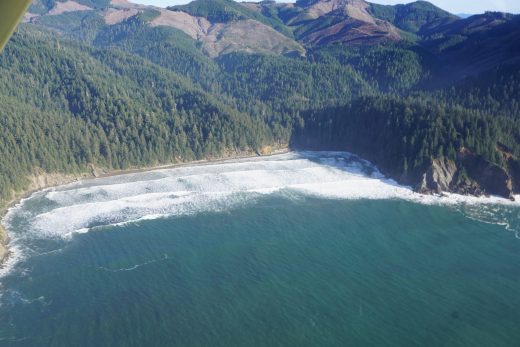
Sea Level Rise could completely change Oregon's most loved places like Short Sand Beach in Oswald West State Park. During the King Tide there is little to no beach at the popular spot.
 Briana Goodwin, Surfrider Foundation | Flight provided by LightHawk
Several locations in Seaside were threatened during the King Tide. Water rose significantly higher towards these houses on 26th Avenue and Pine Street.
 Briana Goodwin, Surfrider Foundation | Flight provided by LightHawk
Just after the peak of the King Tide, water threatened the bus yard across the street from Seaside High School.
 Briana Goodwin, Surfrider Foundation | Flight provided by LightHawk
Many fields along the Nehalem River were flooded and water came close to several structures.
 Briana Goodwin, Surfrider Foundation | Flight provided by LightHawk
King Tides threatened many low lying areas in Astoria as well.
 Briana Goodwin, Surfrider Foundation | Flight provided by LightHawk
