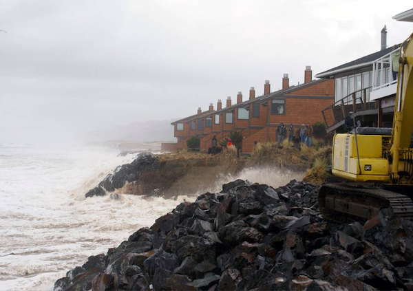
Oregon’s beaches and coastal communities are extremely vulnerable to the impacts of sea level rise. Planning and adapting is more and more a reality that Oregon's coastal communities must face today or else manage some likely dire social impacts from safety and public welfare to the loss of public beaches in the immediate future. Fortunately, the Oregon Department of Land Conservation and Development's Coastal Management Program recently released a Sea Level Rise Adaptation Planning Toolkit, as a critical tool to support coastal communities in planning.
The sea level rise adaptation planning toolkit is a set of three resources for local governments and communities to assess and address the impacts of sea level rise:
1) Sea Level Rise Impact Explorer is a combination of multiple data sources and is meant to serve as a planning tool. There are three main geographies covered by the sea level rise planning area: outer coast, estuaries, and Columbia River. A mix of datasets are displayed for these three geographies and are meant to approximate the areas that will be impacted by sea level rise, using the current best available data. Inclusion of an area in the SLR planning area could mean permanent inundation or that the area will be impacted periodically by high tide flooding, storm surge, or erosion events.
2) Sea Level Rise Impact Assessment Tool is a set of spreadsheets designed to help users inventory what activities take place within affected areas, assess vulnerability to harm, and prioritize further investigation into remedial and adaptive actions. This process can serve as the jurisdiction’s or organization’s vulnerability assessment. Specific instructions for how to use the worksheets is included in the file itself, while a general instructive overview is provided here.
3) Sea Level Rise Planning Guide for Coastal Oregon is a document that provides a suggested approach to evaluate the assets at risk from the impacts of sea level rise and offer potential adaptation strategies to adapt to those impacts within Oregon’s regulatory framework. The guide also provides authoritative information about sea level rise projections and impacts. This document is intended to guide local planning, capital improvement, and development decisions on the Oregon Coast to support community resilience and ensure effective coastal management actions.
All three resources can be found on the Oregon Coastal Atlas website: www.coastalatlas.net/sealevelrise. This is an active area of continued research, and DLCD will continue to update these resources as more data and information become available.
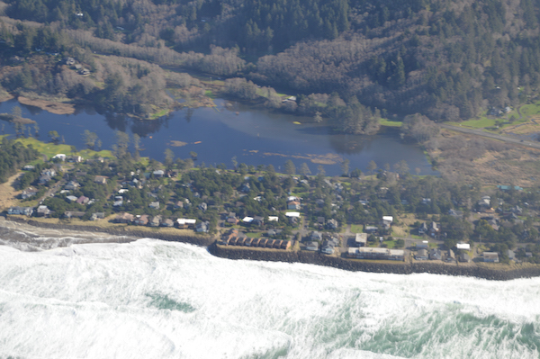 Neskowin armored to "hold the line in sea level rise". What looks like a lake to the east is the golf course inundated during the wet season...open seasonally
Additionally, a 2022-2024 NOAA Coastal Management Fellow has joined the DLCD team to focus on sea level rise adaptation planning and help implement the tools described above. The fellowship project will provide direct capacity to advance sea level rise adaptation planning at the local level in Clatsop County. This will involve hosting community outreach and open house events to identify community assets at risk from sea level rise and working with communities to prioritize and develop sea level rise adaptation measures.
Fellowship Project and SLR Resources Summary Handout
 As a founding member of the Newport, OR Chapter, Charlie has greatly advanced Surfrider's mission through ocean conservation as the Oregon Policy Manager. With a BS in Marine Biology and as a member of the Oregon Ocean Policy Advisory Council, Charlie’s ties to the ocean reach far and wide.