The decision to move the US Coast Guard Helicopter operations from Newport to North Bend has drawn much concern and opposition from the commercial and recreational fishing community, but non-boater recreational users such as unknowing surfers, swimmers and beach-goers likely have more to lose in this murky decision that has ignited statewide opposition. To help represent that recreational and broader community concern, Surfrider Foundation’s Newport Chapter has released a set of story maps based on US Coast Guard incident response data to better visualize and demonstrate statistical grounds for maintaining the helicopter operations within Newport.
Recreational Concerns
Surfers and recreational users have good reason for concern over the closure. Just two weeks after the decision was released to the public to move the helicopter operations, 5 individuals were plucked off the rocks at Fogarty Creek, just north of Newport. The heroic rescue could have very well ended in fatalities had the helicopter taken an hour to reach the scene from North Bend (as it was, they were on the scene within 10 minutes of the call). “Sadly, this happens all too often and seems to be on the rise with tourists and visitors less familiar with our local conditions”, says local surfer Vince Pappalardo. Newport is a hub for tourism and ocean activity, holding some of the most-visited recreational beaches and coastal state parks in the state of Oregon. Again, this past weekend two surfers were rescued by the Newport helicopter near Yaquina Head, once again underscoring these recreational concerns.
The Mapping
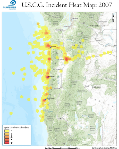
The story map, with its multiple thematic maps, was planned, designed, and executed to provide high-level visibility of the amount of incidents that occur within the current operational area of the Newport based helicopter. Geographic visualization, along with the analysis of a massive 2007-2013 dataset that was provided by the U.S.C.G. under a Freedom of Information Act (FOIA) request, is provided with the maps to give statistical evidence that the U.S.C.G. can't afford to not keep the helicopter in Newport.
“Beyond funding, the initial rationale we received from the U.S.C.G. for moving the helicopter operations came in the form of national trends and statistics that just didn’t effectively represent our local ocean conditions and coastal users”, says Charlie Plybon, Oregon Policy Manager for Surfrider Foundation. “We needed an analysis of U.S.C.G. search and rescue operations for Oregon, not national trends and statistics that lead to poor and uninformed ground-level decisions,” says Plybon.
Surfrider Foundation volunteer Curran McBride heard the need for that local analysis. Two weeks following the FOIA request for the data, Curran got to work developing the maps which provide yearly thematic representation of the amount of incidents that the U.S.C.G. responded to for the 3 stations in Oregon: Astoria, Newport and North Bend. McBride then analyzed the data associated with those incidents for each year to give the user a deeper understanding of the nature of the responses, such as statistics on lives saved or people in the water.
“By capitalizing on the intelligence behind the incident report data and creating a story map from it, I was given the opportunity, as a member of the general public, to tell the story of why it is imperative to keep the Newport air station open forever,” says McBride. “Mapping the past and embedding the historical statistics within has created a powerful tool that I hope will help change the U.S.C.G. policies the next time they consider closing an air station down,” he continued. The maps can be found on Surfrider’s campaign webpage at www.savethehelo.org, by selecting “maps” from the page’s menu.